- Your Government
-
Our Community
-
- About St. Helens History of St. HelensState of the CityCourthouse Dock Camera
- Local Events City Calendar Citizens Day in the Park13 Nights on the RiverSpirit of HalloweentownRecreation Activities Sand Island CampingKeep It Local CC
- Community Resources City Newsletter City Social Media Emergency Services New Resident InformationProtecting Our Environment
-
-
Business & Development
-
- Local Business Directory Get a Business License City Bids & RFPs Broadband Study
- Business in St. Helens St. Helens Advantages Directions & Transportation Incentives & Financing Resources for Businesses Business Guide Columbia Economic Team Chamber of Commerce
- Current City Projects Waterfront Redevelopment Public Safety Facility Strategic Work Plan
-
-
How Do I?
-
- Apply for a Job Apply for a Committee Find A Park Find COVID Info Find Forms Follow St. Helens - Facebook Follow St. Helens - Twitter Follow St. Helens - YouTube
- Get a Police Report Get a Business License Get a Library Card Get a Building Permit Newsletter Signup Past Public Meetings Pay My Water Bill
- Public Records Request Report a Nuisance Register for Rec Activity Reserve a Park Sign Up for the 911 Alerts Universal Fee Schedule
-
Road Alignment Option Selected for St. Helens Waterfront
Plans are moving forward for City improvements along the St. Helens waterfront.
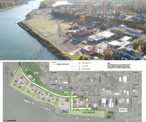
A street alignment option has been selected for the former Boise Veneer property. At the June 16 City Council meeting, Councilors selected a west alignment concept to extend Strand Street and South 1st Street along the property. This decision is part of the Road and Utility Extension Project to extend streets, sidewalks, utilities, and other public amenities along the vacant St. Helens waterfront.
The City Council’s chosen alignment option creates additional public greenspace on the property below the Nob Hill Nature Park bluff (in addition to the planned riverwalk public greenspace immediately adjacent to the Columbia River). The west alignment option also creates larger, more attractive parcels for future development on the site.
All potential development opportunities shown on the proposed design, including the riverwalk path and pedestrian accessway connections, are conceptual only. These improvements will be developed under separate review and approval processes.
The next step for the Road and Utility Extension Project is for the City’s project consultant to complete approximately 30% of the design work. This will give the City an idea of where utilities will be placed on the property and how the roads will connect to adjacent areas. It will also allow the City plenty of opportunity to make changes before a finalized design is created.
It is anticipated that construction will begin in 2022.
To learn more about the City’s waterfront redevelopment efforts, visit our Riverfront Redevelopment page.
Published June 25, 2021

